


| North Facing Camera Click On Play Button To View Live Image |
Sky Facing Camera Click On Image To View Full Screen In New Window 
|


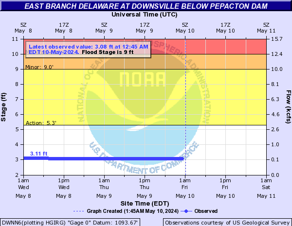
East Branch Delaware At Downsville
| Stage Color Key | |||||
| 5.3 ft - Near Flood | 9 ft - Minor Flood | 10 ft - Moderate Flood | 12 ft - Major Flood | ||
Latest Observation:
Friday April 19th, 2024 03:45 AM EDT
River Status:
Normal
| Height | Flow | |
| Currently | 4.36 ft | 1.44 kcfs |
| Record | 16 ft | 34.000 kcfs |
| Observation | ||||
| Date (EDT) | Stage (ft) | Flow (kcfs) | ||
| Friday 04/19/2024 03:45 AM | 4.36 | 1.44 | ||
| Friday 04/19/2024 03:30 AM | 4.38 | 1.48 | ||
| Friday 04/19/2024 03:15 AM | 4.36 | 1.44 | ||
| Friday 04/19/2024 03:00 AM | 4.35 | 1.43 | ||
| Friday 04/19/2024 02:45 AM | 4.36 | 1.44 | ||
| Friday 04/19/2024 02:30 AM | 4.37 | 1.46 | ||
| Friday 04/19/2024 02:15 AM | 4.40 | 1.51 | ||
| Friday 04/19/2024 02:00 AM | 4.39 | 1.49 | ||
| Friday 04/19/2024 01:45 AM | 4.38 | 1.48 | ||
| Friday 04/19/2024 01:30 AM | 4.38 | 1.48 | ||
| Friday 04/19/2024 01:15 AM | 4.40 | 1.51 | ||
| Friday 04/19/2024 01:00 AM | 4.42 | 1.54 | ||
| Friday 04/19/2024 12:45 AM | 4.41 | 1.53 | ||
| Friday 04/19/2024 12:30 AM | 4.39 | 1.49 | ||
| Friday 04/19/2024 12:15 AM | 4.39 | 1.49 | ||
| Friday 04/19/2024 12:00 AM | 4.40 | 1.51 | ||
| Thursday 04/18/2024 11:45 PM | 4.42 | 1.54 | ||
| Thursday 04/18/2024 11:30 PM | 4.42 | 1.54 | ||
| Thursday 04/18/2024 11:15 PM | 4.41 | 1.53 | ||
| Thursday 04/18/2024 11:00 PM | 4.41 | 1.53 | ||
Data Courtesy of the Advanced Hydrologic Prediction Service
Script Courtesy of Dennis at East Masonville Weather
![[WOW]](WOW.gif)
![[Skywarn]](Skywarn.gif)

![[AWEKAS]](AWEKAS.gif)
![[CANWARN]](canwarn.png)
![[Weather Underground PWS IONOSHAW2]](https://dw7240.com/Base-Canada/wunderground.png)

![[WA]](WA.gif)
![[DAVIS]](DAVIS.gif)
![[anything]](ANYTHING.gif)
![[CoCoRaHS]](cocorahs_can.jpg)
![[MADIS]](MADIS.gif)
![[wcloud]](weathercloud.gif)
![[NOAARADIO]](ani-noaa-radio-small.gif)
![[NOAA]](NOAA.gif)
![[wxtogether]](weather_together.jpg)
![[ipcamlive]](IPCamLive.png)
![[ThingSpeak]](thingspeak.png)

![[MESOWEST]](MESOWEST.gif)
![[PWS]](PWS.gif)
![[COWN]](COWN.gif)
![[CWOP]](CWOP.gif)
![[WEATHERBUG]](WEATHERBUG.png)
![[WINDFINDER]](windfinder.gif)
