Chenango River At Norwich
Back to River Summary
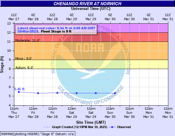
| Stage Color Key |
| 8 - Near Flood |
9 - Minor Flood |
11 - Moderate Flood |
12 - Major Flood |
Latest Observation:
Sunday December 31st, 0000 06:42 PM LMT
River Status:
Old Data
| |
Height |
Flow |
| Currently |
-999 |
N/A |
| Record |
12.8 ft |
N/A |
Data Courtesy of the National Water Prediction Service
Script Courtesy of Dennis at East Masonville Weather
with mods by Saratoga-weather.org
This data is offered only as a general guide to local weather conditions. It should not be relied upon in lieu of officially disseminated weather information for determining possible risk to persons or property.
This site, including all information contained therein, is made available as is without warranties of any kind, either express or implied.
The Vicarage Weather Feed© includes links to other sites for user convenience only.
The content of any linked third-party site is not controlled by The Vicarage Weather Feed©. Access to any third-party website through The Vicarage Weather Feed©, regardless of whether or not the third-party site is a linked site, is entirely at the users own risk.
Externally sourced content or material is excluded from The Vicarage Weather Feed© copyright and is the copyright and property of the respective provider.
Skywarn® and the Skywarn® logo are registered trademarks of the National Oceanic and Atmospheric Administration, used with permission.


![[Skywarn]](Skywarn.gif)

![[WOW]](wow_be.jpg)
![[AWEKAS]](AWEKAS.gif)
![[CANWARN]](canwarn.png)
![[Weather Underground PWS IONOSHAW2]](https://dw7240.com/Base-Canada/wunderground.png)

![[WA]](WA.gif)
![[DAVIS]](DAVIS.gif)
![[anything]](ANYTHING.gif)
![[CoCoRaHS]](cocorahs_can.jpg)
![[MADIS]](MADIS.gif)
![[wcloud]](weathercloud.gif)
![[NOAARADIO]](ani-noaa-radio-small.gif)
![[NOAA]](NOAA.gif)
![[wxtogether]](weather_together.jpg)
![[ipcamlive]](IPCamLive.png)
![[ThingSpeak]](thingspeak.png)

![[MESOWEST]](MESOWEST.gif)
![[PWS]](PWS.gif)
![[COWN]](COWN.gif)
![[CWOP]](CWOP.gif)
![[WEATHERBUG]](WEATHERBUG.png)
![[WINDFINDER]](windfinder.gif)

